Wednesday, June 16, 2010

Back In St. Catharines

What a fantastic vacation that was, and look, we're back in time for my birthday! :D
In order to remember this vacation, I've created a presentation so here it is:

Second Day In Vancouver, British Columbia


Phew! What an exciting day yesterday was!
I felt the energy and what not as soon as I stepped into BC Place Stadium! So exhilarating!
Today, I plan on going to the Van Dusen Botanical Garden and going to see Kooza by Cirque Du Soleil! How exciting!!!
Here are some pictures:
Above: VanDusen Botanical Garden (1)
Below: Kooza by Cirque Du Soleil (2)

What a great vacation this has been! Crazy how fun it was. In the next few days once I arrive back home I will be uploading a video of all the pictures of the places I've been! Well, off to pack to go home!

Links:

(1) http://commons.wikimedia.org/wiki/File:VanDusen_Botanical_Garden_maze.jpg

(2) http://apercevoir.blogspot.com/2009/05/kooza-best-show-ever.html


Arrival In Vancouver, British Columbia

Latitude & Longitude(1): 49°15'N, 123°10'W

Population(2): 2 160 000

Population Density(3): 4.6/km2

Landforms(4): Western Cordillera

Climate(5): Pacific Maritime

Ecozone(6): Pacific Maritime

Closest National Park(7): Mount Revelstoke National Park

Industries(8): Forestry, Urbanization, Agriculture, Fish Processing, Tourism, Recreation

Tourism: B.C. Place Stadium, Large Malls, Botanical Gardens, Cirque Du Soleil ,etc.

Below: Map Of Vancouver (9)


Today we arrive in the final city on our vacation, Vancouver, British Columbia; the famous city of the 2010 Winter Olympics. My favourite thing in the HISTORY OF MAN KIND!!! :D
Ahhhh what to do in the city?

Over the final two days of my vacation I plan on visiting
4 important sites in Vancouver, British Columbia. Today though, I plan on visiting the Metrotown Mall and the BC Place Stadium. Here are some pictures:

Above: BC Place Stadium (10)
Below: Metrotown (11)

Today should be a pretty fun day especially seeing as I'm going to the BC Place Stadium! Ahhh what an exciting day it's gonna be! Well I'm off to get ready.....Bye.......

Links:

(1) http://mapsofworld.com/lat_long/canada-lat-long.html

(2) Making Connections: Canada’s Geography (Textbook)

(3) Making Connections: Canada’s Geography – Pg. 101-116 (Figure 11.1) [Textbook]

(4) Making Connections: Canada’s Geography – Pg. 127-143 (Figure 12.16) [Textbook]

(5) Making Connections: Canada’s Geography – Pg 157 – 165 (Figure 14.2) [Textbook]

(6)http://atlas.nrcan.gc.ca/site/english/maps/reference/national/natpks_e/referencemap_view

(7) Making Connections: Canada’s Geography – Pg 239-402 [Textbook]

(8) Making Connections: Canada’s Geography [Textbook]

(9) http://www.lonelyplanet.com/maps/north-america/canada/vancouver/

(10) http://www.skyscrapercity.com/showthread.php?p=50712907

(11) http://www.dudli-werdenberg.ch/vancouver/bilder-granvilleisland.htm


Second Day In Edmonton, Alberta


Whoa what a day yesterday was!
The Art Gallery of Alberta was sort of a let down. I thought it would've been more exciting and interesting than it was. After we left the boring art gallery, we went to the West Edmonton Mall. HOLY CRAP! What a huge mall!
It was so huge I didn't know what to do. I had such a short t
ime to do all I wanted so I used it wisely. I went to the amusement park for a bit and then spent the rest of my time shopping. I can honestly say I've never bought so many clothes in my lifetime! I think I bought out half the stores and now have a whole new wardrobe!

Today I'm going to be going to the Great Divide Waterfall and Fort Edmonton Park for a relaxing day in the outdoors. Fort Edmonton Park should be the most interesting part because I love history! :)

Here are some pictures of the places I'm going to be visiting:
Above: Great Divide Waterfall (1)
Below: Fort Edmonton Park (2)


Links:
(1) http://www.flickr.com/photos/tjetjep/1051652547/
(2) http://www.shaniaforums.com/showthread.php?t=45364

Monday, June 14, 2010

Arrival In Edmonton, Alberta


Latitude & Longitude(1): 53°30'N, 113°30'W

Population(2): 1 001 600

Population Density(3): 1067.2/km2

Landforms(4): Interior Plains

Climate(5): Boreal

Ecozone(6): Boreal Plains

Closest National Park(7): Elk Island National Park

Industries(8): Forestry, Farming, Tourism, Oil & Gas development
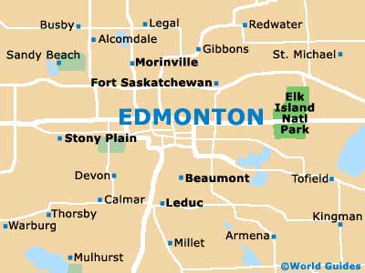
Tourism: Many Art Galleries, Waterfalls, West Edmonton Mall, Fort Edmonton Park etc

Map of Edmonton(9):

Wow! What a crazy vacation it's been so far!
Edmonton by far is gonna be my favourite city! I can't wait to go to the West Edmonton Mall. As I have been from the start of my vacation, I'm going to be spending two days in Edmonton. Over the course of the two days, I'll be visiting numerou
s places. The destinations I've chosen today are the Art Gallery of Alberta and the West Edmonton Mall. Here are some pictures:


Above: Art Gallery Of Alberta (10)
Below: West Edmonton Mall (11)

Overall, today should be really fun! I can't wait to go to the huge amusement park in the West Edmonton Mall! It's gonna be so much fun! I can see it, at the end of the day, i'm gonna be so tired from all the walking and work that I'm gonna have to do there at the mall. Oh well!

Links:

(1) http://mapsofworld.com/lat_long/canada-lat-long.html

(2) Making Connections: Canada’s Geography [Textbook]

(3) Making Connections: Canada’s Geography – Pg. 101-116 (Figure 11.1) [Textbook]

(4) Making Connections: Canada’s Geography – Pg. 127-143 (Figure 12.16) [Textbook]

(5) Making Connections: Canada’s Geography – Pg 157 – 165 (Figure 14.2) [Textbook]

(6)http://atlas.nrcan.gc.ca/site/english/maps/reference/national/natpks_e/referencemap_view

(7) Making Connections: Canada’s Geography – Pg 239-402 [Textbook]

(8) Making Connections: Canada's Geography

(9) http://www.edmonton.world-guides.com/edmonton_maps.html

(10) http://forum.skyscraperpage.com/showthread.php?t=145254&page=58

(11) http://www.easternct.edu/~pocock/MallsWorld.htm

Friday, June 11, 2010

Second Day In Sudbury, Ontario

Today is my second day in Sudbury. Yesterday was a pretty fun day as for going places. Hopefully today will be just as fun!
Today I plan on visiting the Artists On Elgin art gallery and then the Sudbury Kartways. Below are some pictures:

Above: Artists On Elgin Art Gallery (1)
Below: Sudbury Kartways (2)

Today should be super fun because I love to go Go-Karting. I love the feel of the wind rushing through my hair and then thrill that I get from driving these cars around the tracks. Hopefully I don't crash!

Links:

(1) http://www.northernlife.ca/news/lifestyle/2009/nov/artists-on-elgin-051109.aspx
(2) http://www.nckc.net/news/index.asp

Thursday, June 10, 2010

Arrival in Sudbury, Ontario


Latitude & Longitude (1): 46°37'N, 80°48'W

Population(2): 157 857

Population Density(3): 49.3/km2

Landforms(4): Canadian Shield

Climate(5): Boreal

Ecozone(6): Boreal Shield

Closest National Park(7): Pukaskwa National Park

Industries(8): Forestry, Mining, Tourism, Recreation, Trapping

Tourism(9): Many Malls, Art Galleries and things

such as Go-Karting, etc.

Map Of Sudbury(11):
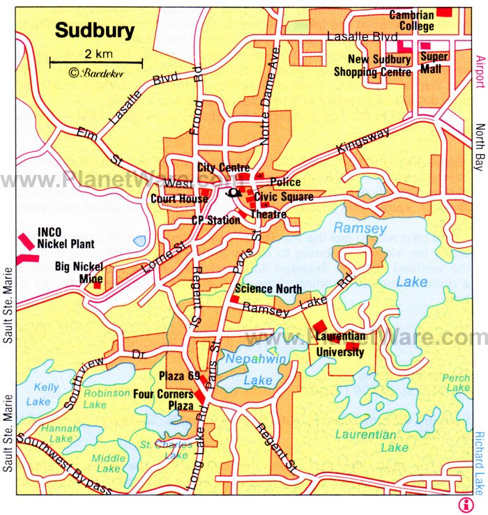
We've officially arrived in Sudbury. I've had just about enough of my brother and parents and having to take a bunch of car rides with them. Hopefully the rest of the trip is worth all this pain and hassle from them! UGH! As for Sudbury, over the next two days I'm going to be visiting many great locations. The highlights for today inSudbury are the New Sudbury Center and La Galerie de Nouvel-Ontario. These two places should be fun as art is my passion and I love spending money on new clothes to wear! Here are some pictures of the two places I'll be visiting:

Above: New Sudbury Centre (9)

Below: La Galerie de Nouvel-Ontario (10)

Links:

(1) http://mapsofworld.com/lat_long/canada-lat-long.html

(2) Making Connections: Canada’s Geography (Textbook)

(3) Making Connections: Canada’s Geography – Pg. 101-116 (Figure 11.1) [Textbook]

(4) Making Connections: Canada’s Geography – Pg. 127-143 (Figure 12.16) [Textbook]

(5) Making Connections: Canada’s Geography – Pg 157 – 165 (Figure 14.2) [Textbook]

(6)http://atlas.nrcan.gc.ca/site/english/maps/reference/national/natpks_e/referencemap_view

(7) Making Connections: Canada’s Geography – Pg 239-402 [Textbook]

(8)

(9) http://www.rainbowcountry.com/members/in/greater-sudbury/new-sudbury-centre

(10) http://gn-o.org/node/1056

(11) http://www.planetware.com/map/sudbury-map-cdn-cdn454.htm


Second Day In Montreal, Quebec

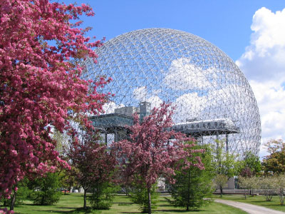
Yesterday was an amazing day. I had so much fun going to the Environment Canada's Biosphere and seeing the concert. Overall, the concert was my favourite because I love classical music.
Today I'm gonna be going to visiting Niacheri’s Secular Work at Musée Du Château Dufrensne and Ultreia Onward Pilgrimage at Marguerite Bourgeoy’s Museum. Here are some pictures:


Above: Marguerite Bourgeoy’s Museum (1)
Below: Marguerite Bourgeoy's Museum (2)

Below: Musée Du Château Dufrensne (3)
Below: Musée Du Château Dufrensne (4)


Hopefully today is as fun as yesterday was. Tomorrow, we'll be on our travels again but this time to go to the beautiful mining city of Sudbury. I don't know how exciting Sudbury is going to be but I'm sure I'll see lots of mines. For now I'm off to explore.....


Links:

(1) http://www.tourisme-montreal.org/Meeting-Planners/Off-site-Venues/marguerite-bourgeoys-museum-and-notre-dame-de-bon-secours-chapel
(2) http://www.museesmontreal.org/main.php?i=25&t=musees&d=1&l=e&
(3) http://grandquebec.com/musees-du-quebec/musee-chateau-dufresne/
(4) http://www.tourisme-montreal.org/What-To-Do/Attractions/musee-du-cheteau-dufresne

Arrival in Montreal, Quebec


Latitude & Longitude: 47°14'N, 84°39'W

Population: 375 0

00

Population Density: 4439/km2

Landforms: Canadian Shield

Climate: South Eastern

Ecozone: Boreal Shield

Closest National Park: La Mauricie National Park

Industries: Forestry, Mining, Tourism, Recreation, Trapping

Tourism: Many concerts/Concert halls, Museums, Festivals, Science-oriented Exhibits, etc

Below: Map Of Montreal (12)

After a long car ride, we've finally arrived in beautiful Montreal, Quebec!
The weather is beautiful. The sun is shining. I can tell that I'm going to LOVE it here!
Over the next two days that we're spending in Montreal, I plan on going to many places.
Today I'm going to go to see Vivavoce; a Three Concert Series at the Redpath Hall
and also Tic Tac Tox at Environment Canada's Biosphere. Here are some pictures:
Above: Vivavoce Concert (9)
Below: Redpath Hall (10)

Below: Environment Canada's Biosphere (11)


Hopefully seeing both these places/events will be worth while. I guess I'll just have to wait and find out. That's all for now. Hopefully tomorrow will be just as fun as today should be!

Links:

(1) http://mapsofworld.com/lat_long/canada-lat-long.html

(2) Making Connections: Canada’s Geography (Textbook)

(3) Making Connections: Canada’s Geography – Pg. 101-116 (Figure 11.1) [Textbook]

(4) Making Connections: Canada’s Geography – Pg. 127-143 (Figure 12.16) [Textbook]

(5) Making Connections: Canada’s Geography – Pg 157 – 165 (Figure 14.2) [Textbook]

(6)http://atlas.nrcan.gc.ca/site/english/maps/reference/national/natpks_e/referencemap_view

(7) Making Connections: Canada’s Geography – Pg 239-402 [Textbook]

(8) Making Connections: Canada's Geography

(9) http://www.meetmarketadventures.com/graphics/2008-11/mmapi__000009391.jpg

(10) http://www.flickr.com/photos/theenginedriver/2904183887/

(11) http://www.gothereguide.com/biosphere+montreal-place/

(12) http://www.lonelyplanet.com/maps/north-america/canada/montreal/

Monday, June 7, 2010

My Second Day In Halifax


It's the morning of our second day in Halifax, Nova Scotia. It's about 9 A.M. and I'm going to be leaving to go to the Christ Church for our Sunday service in about 15 minutes. As for the agenda for today, it looks like I'll be going to the Christ Church and then probably going to the Art Gallery of Nova Scotia to look at all the exhibits. H
ere's some pictures of the places I'm going to today:

Above: Christ Church in Nova Scotia (1)
Below: Art Gallery Of Nova Scotia (2)


Today should be an interesting day but over the next few days I will be moving to my next vacation city, Montreal, Quebec. Hopefully I have as much fun in Montreal as I am having here in Halifax!

Links:

(1) http://www.christchurchdartmouth.ns.ca/
(2) http://www.artgalleryofnovascotia.ca/en/landing.aspx

Tuesday, June 1, 2010

Arrival In Halifax, Nova Scotia


Over the past few days we have been driving out to Halifax, Nova Scotia and finally we arrived at 12: 15 P.M.

Here are some facts about Halifax, Nova Scotia:

Latitude & Longitude(1): 44°38'N, 63°35'W

Population(2): 375 000

Population Density(3): 67.9/km2

Landforms(4): Appalachians

Climate(5): Atlantic Maritime

Ecozone(6): Atlantic Maritime

Closest National Park(7): Kejimkujik National Park

Industries(8): Forestry, Agriculture, Fishing, Tourism, Urbanization

Tourism: Churches, Art Galleries, Parks, War Museums, Aviation Museums, etc.

Below: A map of Halifax (9)
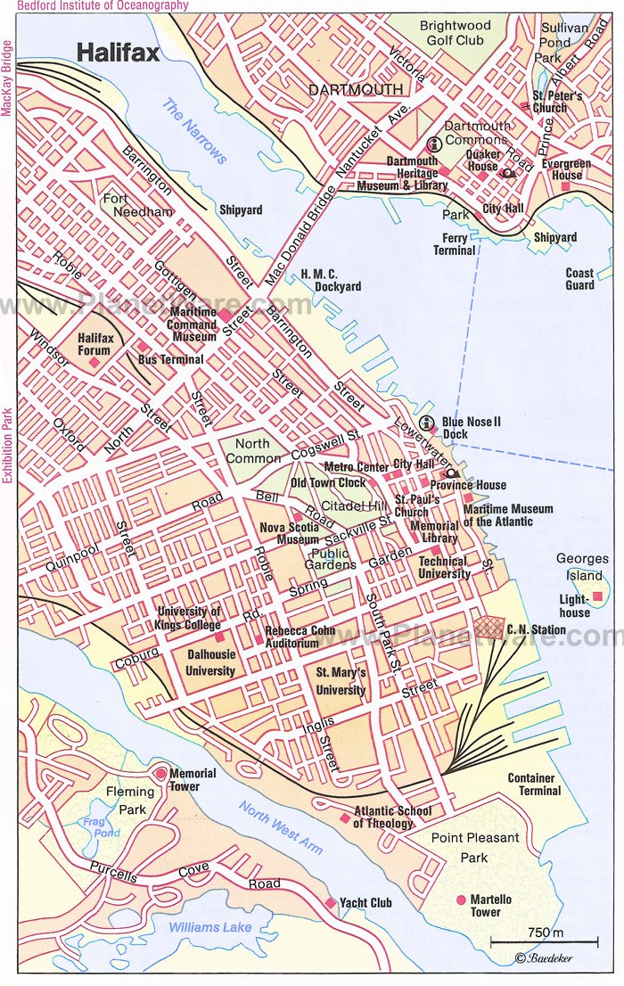

As soon as we arrived in Halifax earlier this afternoon, we decided to start exploring. As we were driving around the city, we noticed some interesting museums and Art Galleries. Along our travels, we decided to stop at the Anna Leo
nowens Gallery. I must say, it's a FABULOUS gallery which showcases many different artists' paintings. Here are some pictures:


Above: Picture of the Anna Leonowens Gallery in Halifax (10)
Above: Another Pictrue of the Anna Leonowens Gallery in Nova Scotia (11)

Also while on our journey through the city, we stopped at Bishops Park for a nice relaxation during the hectic day. While in the park, we sat on the benches and watched the birds fly by and enjoyed the fresh air of Halifax. Here's a picture (12):


Today was overall a pretty hectic day but tomorrow will be relaxing. I plan on going to church with my family seeing as tomorrow will be Sunday and possibly going to the War Museum. Who knows what tomorrow will bring!

Links:

(1) http://mapsofworld.com/lat_long/canada-lat-long.html

(2) Making Connections: Canada’s Geography (Textbook)

(3) Making Connections: Canada’s Geography – Pg. 101-116 (Figure 11.1) [Textbook]

(4) Making Connections: Canada’s Geography – Pg. 127-143 (Figure 12.16) [Textbook]

(5) Making Connections: Canada’s Geography – Pg 157 – 165 (Figure 14.2) [Textbook]

(6)http://atlas.nrcan.gc.ca/site/english/maps/reference/national/natpks_e/referencemap_view

(7) Making Connections: Canada’s Geography – Pg 239-402 [Textbook]

(8) Making Connections: Canada's Geography [Textbook]

(9) http://www.planetware.com/map/halifax-map-cdn-cdn236_n.htm

(10) http://www.juliagalloway.com/making_history/exhibition.html

(11) http://www.halifaxinfo.com/museums-galleries.php?getSearch=66

(12) http://www.thetourismcompany.com/project.asp?serviceid=7&projectid=1149


My Vacation

Over the month of July, I will be travelling across Canada for a vacation with my family and spending a total of two days in each city. As I'm travelling, I will update this blog with posts about where I'm staying with information such as the geographic location, landforms and other information like that as well as pictures and maps. For my vacation, I've chosen to visit:

  • Halifax, Nova Scotia
  • Montreal, Quebec
  • Sudbury, Ontario
  • Edmonton, Alberta
  • Vancouver, British Columbia
Overall, this will probably be the most exciting experience and vacation I've ever been on in my life. Hopefully the weather is not too humid, hot or windy in these cities because if it is, all the touring I will be doing will become a whole lot more work!

Anyway, here goes my vacation!
Gotta run to pack.....We're leaving tomorrow, July 4th, 2010!